The language of aviation worldwide is officially English—it is what all international pilots and air traffic controllers must converse in. But any pilot will tell you that the real language of aviation is the acronym.
Table of Contents
The OBS is a selector knob on a navigational radio. It stands for the “Omni-Bearing Selector,” and it enables a pilot to select which direction they wish to fly towards or away from a VOR navigational beacon or GPS waypoint.
What is an OBS?
Simply put, an OBS (Omni-Bearing Selector) is just another nondescript knob in an airplane’s cockpit. It controls the pilot’s navigational instrument. Initially, OBSs were connected to a NAV indicator that worked with a VOR receiver. These navigational radios receive VHF (Very-High Frequency) signals from a VOR (VHF Omnidirectional Range) ground station.
The locations of VOR stations are shown on aeronautical charts, along with their frequencies. The pilot can input the frequency and then navigate using that ground station.
The OBS controls the display in the cockpit to tell the pilot different things about the station. For example, the instrument can tell the pilot the course to fly either directly toward or away from the VOR by turning the OBS.
How Do VOR Stations Work?
To understand how the OBS works, it’s important to understand the basic functionality of a VOR.
VORs make up the backbone of aerial navigation technology. They’ve been widely used since the 1930s—and they’re still important today. Of course, GPS satellite navigation is taking over, but VORs serve as an important backup for pilots if their GPS receivers fail.
The NAS (National Airspace System) is fundamentally built on an extensive network of VORs. They are connected to one another with a series of routes known as airways. Pilots know they’re on an airway by setting the OBS to match the airway course printed on the chart.
In the United States, airways between VORs under 18,000 feet are called “Victor Airways” since they all begin with the letter “V.” Above 18,000 feet, they are called “Jet Routes.”

How Do You Use an OBS?
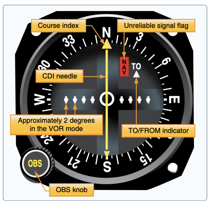
In traditional round-dial equipped aircraft, an OBS knob was located on the NAV indicators. Spinning the OBS moves the compass card behind the instrument. To select a specific radial on a VOR, the pilot puts that radial at the top of the instrument.
The needle on the NAV instrument is called the CDI, or Course Deviation Indicator. Moving the OBS knob will cause the CDI to swing around on the dial. When the CDI is centered, it gives the pilot some information about where they are.
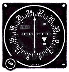
Another essential feature of the NAV instrument is the TO/FROM Indicator. Where ever a plane is located, the pilot can center the CDI needle two times—once with an OBS course selected that will take the plane to the VOR (TO indicated), and once with the OBS course selected that will take the plane directly away from the VOR (FROM indicated).
OBS vs CDI
Both of these components are found on a navigation radio, and they are connected to one another. The OBS (Omni-Bearing Selector) is the knob that the pilot adjusts.
On the other hand, the CDI (Course Deviation Indicator) is the needle in the window that shows your desired course. So the pilot turns and sets the OBS but sees their course by looking at the CDI needle.
How Do You Use a Horizontal Situation Indicator (HSI)?
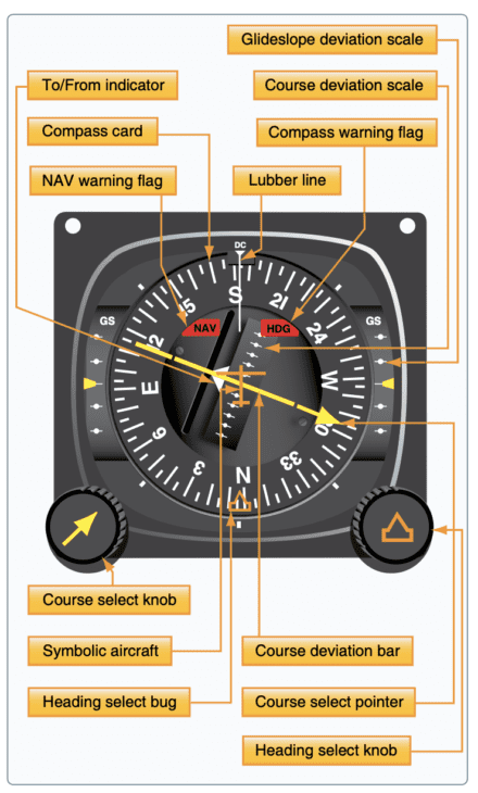
A more advanced variation of the basic NAV instrument is the HSI, or Horizontal Situation Indicator. This device combines a few important things on the instrument panel into one. The idea is to reduce a pilot’s workload by giving them fewer places to look.
The HSI contains all of the parts of a regular NAV instrument—including an OBS and a CDI. But these are mounted inside of a directional gyroscope or heading indicator.
That’s handy when compared to a traditional NAV instrument, which does not take the aircraft’s heading into consideration. Instead, the pilot must interpret the readings of the two instruments separately to get a complete picture of the aircraft’s position.
HSIs are more advanced and a lot more expensive, so they’re usually only found in larger or newer planes.
What About Glass Cockpits?
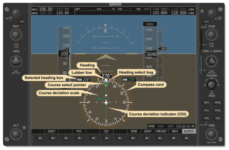
Despite this, the HSI is becoming more and more common in airplanes. Digital technology and glass cockpits make creating this type of instrument interface in cockpits a lot easier. As a result, an HSI is a standard part of all digital and glass cockpit instruments.
What’s more, glass cockpits enable the software to use the HSIs CDI needle for any navigational source that the plane is equipped with. Most HSIs can display two or three navigational radio signals all at the same time!

What is OBS Mode on the G1000?
Today, many planes, especially those with glass cockpits like the Garmin G1000, have VFR and IFR-approved GPS (Global Positioning Systems) receivers. So it only makes sense that the HSI can display course guidance from that, too.
All aircraft GPS units have two modes. They can either fly directly towards something and display the route there like a road. The pilot follows the road, and the CDI on the navigational instrument simply indicates where that road is.
On the other hand, they can select OBS mode. That will enable them to choose the course they want to fly to the selected waypoint. They can then fly TO or FROM it precisely as if it were a VOR.
How Does an OBS Work on a GPS?
Aviation GPSs have always been tied into the same NAV indicator on the panel that the old-school VOR used. This made using the two systems very easy for pilots because it meant that the two types of NAV “flew” very similarly.
Despite how it looks in the cockpit, the truth is that GPS and VOR are very different technologies. VORs are ground-based and have a limited range—usually less than 100-200 nautical miles. They also get less accurate the farther away from the source that the pilot is.
GPS, on the other hand, works anywhere on earth. The signals come from satellites orbiting above, which means you can never be “out of range.” It also means there’s no actual ground station to be navigating TO or FROM.
So to make it more user-friendly, aviation GPS units are programmed with a database of waypoints built in. All existing VORs and airports are in the database. So too are intersections and fixes that used to be defined by VOR airways.
Once a pilot selects a waypoint from the database to navigate TO or FROM, they can then use the NAV indicator with its OBS and CDI, just like they would when navigating with a VOR. But in this case, they can navigate that way to any point, be it an airport, a fix, or a navigational aid.
References ▾
Related Posts

